An interesting thing on the way to the power plant

One a little photo trip last weekend I stopped near Heskett Station, our local power plant. There’s a little fishing area nearby and, while I don’t fish, I do have an interest in the river right now. I thought I’d take a peek and see what the Big Muddy looked like from “the other side of the river.” I caught an interesting sight.

These metal steps normally take one down to the river bank. Some industrious soul painted numbers on the steps here, presumably before the river level began to rise so dramatically. At the time I visited this point last Saturday morning, the first step visible above water was number nine, and just barely at that. Since the releases had been throttled up a bit the day before, it’s entirely possible that the water later covered up #9.


Releases from Garrison Dam have been throttled back to 145,000cfs as of yesterday afternoon.
With that in mind, and barring any unforeseen circumstances requiring an increase, we may have already seen the water at its highest. Let’s hope so, eh? While the photos are more dramatic when the water is high, I’m more concerned about the people whose homes and businesses are in the water right now. Hopefully they can start to get their lives and property back to normal as soon as possible.

Hey…this irrigation stuff really works!

I hope a little “flood humor” at a time like this isn’t inappropriate. I couldn’t help but appreciate a little bit of irony at the sight of this irrigation rig up to its wheels in water. This is on the Mandan side, where many of these rigs populate the landscape. From time to time I could see their blue strobes flashing at night from my stargazing vantage point near Double Ditch, and for the longest time I wondered what they were. They’re unlikely to be needed in this area for a while, I presume, or in many other areas around North Dakota.

This raises another question: how many acres in North Dakota have gone unplanted this year due to water-related concerns, flooding or saturation? The answer is scary.

Tale of two ditches. Double ditches, technically

This is a photo from nearly one year ago, taken from one of my favorite Missouri River vantage points: the old fence post at the north end of Double Ditch Indian Village. Pay close attention to this view, because…

…it now looks dramatically different, as can be expected with an astonishing amount of water coming down the valley. All the sandbars, trees, and backwater channels are now simply part of The Big Muddy.

By the way, photos like these just got harder to come by. The reason for that is right here: the ominous ROAD CLOSED sign. Like many scenic areas around Bismarck-Mandan, this area is now off limit to vehicles. Actually, I was surprised to find it open to the public a couple of nights ago when I came up here for some thunderstorm photos. Why, you may ask? Read on.

The cliffs of Double Ditch have been gradually succumbing to erosion for as long as I can remember. Large slabs of dirt occasionally simply fall into the river, and that’s when the mighty Missouri is at normal levels. Now that it’s four feet above flood stage an dmoving at several times its normal velocity, it just got more precarious. I put a camera on a pole and held it toward the edge for this photo, and I have no intention of going back.

It looks like a section of the cliffs further south has collapsed dramatically, opening up a chasm very near to the road. If so, that’s the most plausible reason for the closure. If not, it’s still a wise precaution given the instability of the park’s western edge. That’s not the area shown in the photo above; I didn’t want to walk that far. By the way, this photo was taken by holding out a pole with a camera on the end – I don’t have a death wish.

I highly recommend against getting curious because these cliffs are likely to recede even further as the river takes its toll. I guess the park is one more casualty of the Flood of 2011, even though it’ll never be under water.

Poor Corps…it’s been a bad week for PR. How much do we trust ’em?


While I won’t join the cacophony of detractors claiming that the Army Corps of Engineers should have possessed some sort of “crystal ball” to foresee the weather conditions which have brought us to this point, I do think they need a remedial lesson in being forthcoming. I have a hard time believing that they didn’t know that a 55kcfs release rate would not eventually have to be throttled up to the 150kcfs rate. Burleigh County Commissioner Mark Armstrong has been trying to wring details out of them without result, leading to distrust and wild theory.


One of the theories making the rounds out there is the one I just linked above using Scribd: It’s a man who has spent plenty of time around the Missouri River system and claims that Fort Peck Dam is like a “first domino” (those words are mine) in a potentially greater failure which could cut a deep swath through a good portion of the Midwest.


Then you get the photo posted above on the Corps’ own Flickr feed. It shows one of their people pounding in a warning sign and fence near Fort Peck while the bank crumbles into the lake behind them. That’s reassuring, isn’t it?

Granted, the Shanks fella who I referred to a couple of paragraphs back has two strikes against him: first, he works for an environmentalist advocacy group; and second, he has an upcoming book release on this very subject. What better way to drum up interest? He does, however, raise some interesting questions.


Then, of course, you have to wonder about this: an emergency bid being put out for the material which reinforces the Fort Peck Dam, the very one Mr. Shanks claims is the weak link and which is already at 111% of its flood control capacity.

These would likely be defused as a “smoking gun” if the Corps would simply be a little more forthcoming. I know there are some answers which nobody can have on hand, but I find myself sitting here wondering when the 175kcfs shoe is gonna drop. If it does, we’ve got some serious issues to deal with.

The local dikes are built with the mantra “twenty point six plus one” in mind. Suppose the Corps chooses to, or is forced to, increase releases past the 150kcfs mark? Could we build all of those levees even higher still, even if we wanted to? And that leads me back to my original question: why did our local officials even take them at their word in regard to the 150kcfs number, after they’ve constantly moved the goal posts on us?

While Garrison is down a bit, Fort Peck’s inflows are 150% of their outflows…and again, that reservoir is at 111% of Flood Control storage capacity without the spring runoff even starting yet. If the Corps has a plan for this mess, I think they need to be forthcoming with answers to people’s concerns. I still think that anyone who relies on the Corps’ current numbers to have any finality is fooling themselves.

I’m not trying to feed the rumor mill here, so don’t take this post the wrong way. What I am saying is that there are a lot of really inconvenient tidbits of partial information floating around out there, and they can really be used to feed the hysteria if treated improperly or if people are left to try to find their own information and let their imaginations wander.

And if you haven’t already thrown the kids and the photo albums in the car and fled screaming for the hills, you may wish to read this recently posted response by the man in charge of the Omaha District of the Army Corps of Engineers, posted on the Bismarck city website.

Despite that recent assurance, I think the Army Corps of Engineers needs to be more forthcoming while attempting to reassure people that they do have a plan in detail. As far as the people who have decided that Bismarck and Mandan are building to the “twenty point six plus one” is the end of our dike-building, I wish only to remind them how quickly 55,000cfs turned into 150,000cfs…only a matter of days. They need to try to keep the Corps accountable, and if further planning and preparation are needed this is the time to make sure that they happen.

Welcome to Bismarck-Mandan, home of the No-Fly Zone

Just in case you thought you might find a way to hop a flight with a pilot friend and get your own birds-eye view of the flooding situation, I thought I’d pass along this little tidbit: Bismarck-Mandan is a no fly zone for air traffic below 5000 ft MSL, shown in the red area above.

The FAA put out NOTAM (Notice To AirMen) 1/6326 on June 5th with very specific instructions that really don’t leave local pilots much room. My guess is that they fear that the same bunch of lookey-loo gapers that caused traffic jams from one end of the metro area to the other will find a way to take to the air, and that causes a hazardous situation over an area where a rescue is a near-certain impossibility.

Oh yeah…right before that they issued NOTAM 1/6325, which declares the same sort of thing around Garrison Dam. So if you thought it’d be really keen to hop in a puddle-jumper and do some circles around the dam to satisfy your curiosity, guess again!

You can find the two NOTAM bulletins on the FAA website here:

FAA NOTAM 1/6326 (Bismarck-Mandan)

FAA NOTAM 1/6325 (Garrison Dam)

Umbrage, and some useful links to boot

I couldn’t help but wince a bit when someone at a daily Missouri River Flood Briefing repeatedly mentioned misinformation on “the blogs” and by “the bloggers” a couple of days ago. Personally, I was sitting in one of the Operations Centers doing my job instead of blogging, but I was still a little put out by that remark.

I don’t know there WERE so many Bismarck- or Mandan-specific blogs, actually. I like Randy Hoffman’s site and (even though we’re ideological opposites) I enjoy Cat’s writing. So who’s spreading all the misinformation?

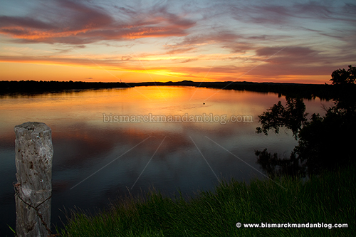
Well, certainly it isn’t me. In fact, aside from some campy photos of the swamped riverboat, I’ve been far too busy to even get out an see the flooding in person. Even if I did, I think the past several years have proved that I’ve behaved responsibly overall in what, where, when, and how I post stuff on this site.

I guess it’s not so much personal offense as it is the way many people speak about “bloggers” with disdain. Having worked in the communications industry for decades, I could cite plenty of examples of irresponsible journalism from various media outlets in this town. Having a set of call letters or a printing press doesn’t give you any more credibility than the guy who has discovered a story and wants to articulate it.

Being a “citizen journalist” or “blogger” doesn’t make one righteous or noble, either; however, anyone who claims having a J-school degree somehow gives you a)credibility, b)accuracy, or c)integrity needs to wake up and smell the coffee.

As you should have deduced by now, I’m an information junkie. As usual, I have a few links that you may find useful. Rather than act like I have all the answers, I like to point you to the people who do. I haven’t seen these linked anywhere else, so here goes:

If you’re wondering what the river stage is at various measuring points, just click below:

waterdata.usgs.gov
 

You can find all kinds of data about the Missouri and other rivers in our area with graphs of all by clicking below:

www.crh.noaa.gov
 

This page will give you the daily water release orders issued for the Garrison Dam within the Army Corps of Engineers:

usace.army.mil Orders page
 

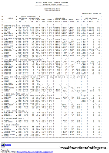
My favorite, which gives you a TON of information about just about every aspect of the various dams and reservoirs in our area of concern, can be viewed by clicking below:

usace.army.mil Reports page
 

There’s quite a variety of information available at the US Army Corps of Engineers’ Missouri River Basin Water Management Division’s website, just click below:

usace.army.mil NWD-MR page

I said it before, I’ll say it again: I don’t pretend to have all the answers, but I probably have some hyperlinks to help you inform yourself. Having said that ad nauseum and after posting all those links to dizzying information above, let me point this out:

bismarck.org and cityofmandan.com are STILL your best bet for reliable information.
Not facebook, not your neigbor, not even local media.

Do yourself a favor and find your own information from the source. Find out your home’s elevation, watch the river, learn what a river release rate means in relation to a river stage level and how that stage level relates to elevation. Once you get your noodle wrapped around triangulating rate/stage/elevation, you will be able to assess your flood risk very quickly. Better yet, you’ll see through much of the other misinformation.

What a difference seven years can make…twice

With all this talk of how high the Missouri River will be due to releases from a full Lake Sakakawea, I was reminded of a time not too long ago where the big lake was in the hurtlocker, desperately in need of water. I looked back in my photo collection and was quickly able to find these examples.

I was on a motorcycle trip and found myself in the Pick City – Riverdale area, and stopped on the east end of the Garrison Dam to eyeball things a little. I was amazed to see that the water wasn’t even anywhere near the spillway gates. In fact, I was able to walk up to them on dry land. Sensing an opportunity, I did so.

Here you can see the markers for observing the lake level, something quite unnecessary in this photo. I could remember back in 1997, when water was lapping over the top of these monster spillway gates. Fast forward seven years, and they were facing nothing but sand and sediment.

Of course, here we are another seven years out from the Flood of ’97, and the pendulum has once again swung in the direction of overwhelming amounts of water. I haven’t had the opportunity to visit the dam this spring, but I imagine it’s quite a sight. It’s interesting how we’ve seen such wild extremes in seven year intervals.

Remember this post in 2018, if it’s dry and we’re desperately in need of water! What a difference seven years can make.

Looking for a riverboat ride…how far can you jump?

I was among the many curious locals who traveled up and down along the Missouri River recently to investigate the notoriously high water level. I’d heard that the river was going to rise by approximately five feet, but wanted to see for myself what a difference that would make. The answer: significant.

The most dramatic illustration of the risen Big Muddy is at the Lewis & Clark Riverboat landing. Maybe they can come up with some sort of a “mini riverboat” to ferry passengers out to the real thing! The moorings for this boat are out quite a ways and now underwater, leaving no easy solution. I’m guessing a catapult or fast-line rope rig are out of the question.