

Naturally we are seat belt users in our family. As a passenger in a friend’s car, I once went partially through a windshield. If my knee hadn’t gone through the dashboard I probably would have been ejected completely. It opened my eyes and I’ve been an ardent supporter of seat belt use ever since.
By the way, I don’t believe in seat belt laws for adults, but I do encourage their use. The same thing goes for helmet use; as a former motorcycle racer, I’ve ruined multiple helmets but kept my head intact as a result. I’m not going to go around trying to force others to wear seat belts and helmets, but I will give an enthusiastic testimony of their effectiveness.
Sometimes, of course, people just have to see for themselves, and that’s what this machine is all about. In addition to my fatherly guidance, I’m hoping demonstrations like this will open the eyes of my boys as well!

Here’s to you, my little loves, with blessing from above, now let the Day begin.
I’ve been awfully busy lately, and that has been reflected here on the ol’ Blog. In addition to husband and Daddy time, I’ve had a lot of freelance work and been building a new monster computer for my photo and video work. A guy’s got to have priorities. I have managed a little bit of photography from time to time, it’s just a matter of getting it posted here. Soon…very soon.
This is the day which the LORD hath made; we will rejoice and be glad in it. -Psalm 118:24

“The eight students named in the lawsuit are not members of the two Sioux tribes in North Dakota…”
There you have it. This entire controversy was sparked when a bunch of out-of-state liberals at the NCAA decided that the logo and nickname, granted to the college approximately forty years ago, were “hostile and abusive.” I’ve got a little graphic for ya:

But if the logo’s got to go, I’ve got an alternative:

Not only could we honor the pioneer spirit, then we could let every OTHER minority have a piece of the victimhood game. Right now it’s just one group of sniveling activists mad about the UND logo and nickname. Think how many groups could come out of the woodwork and get their 15 minutes of fame if we had a logo and nickname that honors the majority of the population of our great state!
Of course, I say all this in the name of satire to highlight how silly the “controversy” is. I see people say online and hear in the halls of the state legislature that the issue is a “waste of time” and that there are more important issues than just a logo. For the last time in this post, I will reiterate that this is about more than just a logo and nickname. This is about standing up to out-of-state busy-body activism in the name of “politically correct” tyranny. If this is the front on which this battle will be waged, then let’s fight it with the bravery and tenacity of the Fighting Sioux.


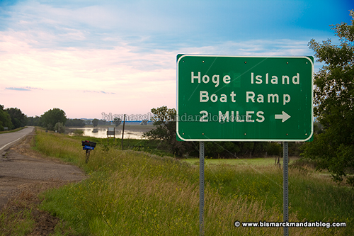
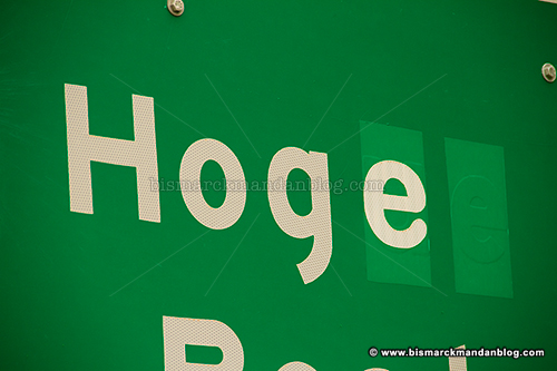
Bringing this up to Mark, he told me to “read the signs!” Always willing to double check myself, I decided to take the long way home after work and investigate. Guess what: Hoge. Look above and see for yourself. Case closed, right? Nope.
I was hoping that it might be as simple as looking for a Hoge Township on the Burleigh County map (PDF), but sadly that did not yield the intended result. Burleigh County itself refers to the area as Hoge Island. So how do I try to get an authoritative, definitive answer?
Well, while I’ve actually been wondering about this since late May or early June, it turns out that the Bismarck Tribune has been on top of it. They did this story on the matter back in June and discovered that two branches of the family which once owned the land in the area spelled their last name in two different ways. So we’re BOTH right. Thanks to Chris Bjorke for the legwork on this one.
I knew a guy in college whose last name is Hoag. I wonder if he’d want to chime in on the matter

The machine pictured above, visible on the west side of Highway 83 as you approach Minot, has sat broken for many weeks. I think it’s a pretty good picture of the dependability of wind power. When there’s not enough wind, they don’t function. When there’s too much wind, they don’t function. When they do, they put the hippies in a quandary when they start killing birds in the name of being “Green™.” Oh yeah…and they’re LOUD.
I “re-appropriated” the title of this post from the folks at Envirogy, a website which has collected a number of studies dispelling the myth of wind power as a panacea. In fact, the opposite could be demonstrated to be true. Compiling studies from places such as windaction.org, they are able to point out the flaws in the utopian view of impact-free windmills churning peacefully across the fruited plane, freeing us from the shackles of evil corporations. Take a look at this article and the studies linked therein.

There you have it, the musings of someone who doesn’t drink the “renewable energy” Kool-Aid, some web links to provide a little weekend reading, and of course another windmill photo of sorts. Have a great weekend!
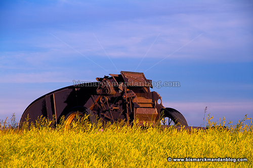
That’s where the calendar comes into play. In mid-June when the days are longest, the sun sets farther north than during most of the year. At that point it’s just far enough to illuminate part of this machine, as you can see here. It still has a shadow cast along part of the side, but at least the main workings are seeing direct light.
One of the things that has intrigued me the most about photography, at least the type of photography which I pursue, is that timing is everything. I’ve taken photos of this machine during the summer, winter, and all points in between. It wasn’t until I made a point of remembering to visit in late June that I was finally able to get a shot like this one. Maybe next June I’ll try it at sunrise!

While I did not catch any of the faint meteors on camera, we did see some spectacular ones and plenty of satellites. Of course, when the really amazing ones with glittery trails came by, I wasn’t in the process of taking a photo…so I came back empty-handed in that regard.
Taking photos of the starry sky requires a lot of things to go right. We need a clear sky, no wind, and decent temperatures for the long exposures. One other thing we need is for the camera to NOT fog up. Sadly, it did just that as a wave of fog rolled in just before we decided to call an end to the evening.
The heavens declare the glory of God; and the firmament sheweth his handywork. -Psalm 19:1
The most notable passage I’ve read so far is where Todd Lindquist writes, “I’m headed home. I no longer look people in the eye and tell them the forecast is 85,000 cfs from Garrison.” As it turns out, releases would eventually exceed that number by another 70,000 cfs… a fact North Dakota would be told only gradually.
There have been plenty of people making the case that the river was horribly mismanaged prior to the flood event. I wouldn’t argue with that. Now it’s time to figure out where everything went sideways and to prevent it from happening again.
In a way, I have a lot of sympathy for the Corps of Engineers; after all, they have strict guidelines to which they must adhere, guidelines which result in quite a juggling act as they struggle to make many competing interests happy. That’s quite an unenviable position.
Any investigation and resulting action that is taken in the aftermath of the Missouri River flood needs to be more than a simple headhunt. It also needs to take a long, hard look at the way the Missouri river system master management manual is written. Perhaps the dams should be returned to their original intended purpose: flood control. That way when barge traffic, recreation, and an endangered bird begin to cause mismanagement of the system, people’s lives and property don’t become casualties of the resulting mess.