Great minds think alike, and so do ours

The other day I hopped on one of my motorcycles for a short ride, and I happened upon the area near the Grant Marsh Bridge. There were a few photogenic things to capture in the area, and a motorcycle doesn’t take up much space, so I was able to pull over briefly without interrupting traffic on River Road or crossing any barricades.

This keelboat seems to have been built in just the right spot for a 500-year flood event. The water comes right up to it, but even at such record levels it doesn’t actually flood out the boat. It’s almost as if it was designed for a day like today.

Even the walkway is dry, despite flooded land all around. Too bad the area is blocked off, this would actually be a nice little tourist-y spot for all the gapers that have been driving 20 miles an hour up and down River Road for the past few weeks!

Here’s a good vantage point for the flood, if you’ve got waders on…or perhaps clothing and shoes you don’t mind getting wet. Which reminds me, my buddy and former coworker Mark Armstrong got the same idea I did, because I saw him there just after I went north to Pioneer Park and turned around to head back south into town. He was busy with his camcorder, so I didn’t stop to interrupt. Here’s the video he was shooting:

Great minds think alike…and so do ours!

Pioneer Water Park, plus a quick profile

One of the most dramatic and accessible (sorta) sites for local residents to gauge the impact of the Missouri River flooding has got to be Pioneer Park. It’s easy to get a point of reference as far as how high the water is, it’s right along the road, and it’s a feature that most residents have probably seen quite often before and since the flooding began.

Picnic tables have been relocated as they’ve become somewhat bouyant, getting hung up on other park features. The volleyball nets look more like tennis nets right now, and who knows what the sand in the courts will look like when the water recedes?

Don’t forget to call and make your reservation! Actually, I think the mosquitoes have this place booked solid for the next couple of months. It’s actually a CLOUD of bugs down there right now, and I’ve got the bites to prove it. In addition to water damage, Bismarck-Mandan is going to have a lot of insect control to perform with all this water. Those plans have already begun.

The state Water Commission has released a recent river profile and it has some very interesting results. Some areas have been dug deeper, some have been filled in, and overall the river is, as I’ve heard it described, “active.” Just what the Missouri River looks like, including the channel, banks, and sandbars (or lack thereof), will be very interesting once the waters recede. I don’t know of anyone making any solid predictions on that right now.

Let’s just hope we get through this without further loss of property and that we can begin the recovery process. Minot has it even worse than we do, but one remarkable statistic throughout all of this North Dakota flooding is that we have not lost one single life to the disaster. That’s got to be the best news so far.

An interesting thing on the way to the power plant

One a little photo trip last weekend I stopped near Heskett Station, our local power plant. There’s a little fishing area nearby and, while I don’t fish, I do have an interest in the river right now. I thought I’d take a peek and see what the Big Muddy looked like from “the other side of the river.” I caught an interesting sight.

These metal steps normally take one down to the river bank. Some industrious soul painted numbers on the steps here, presumably before the river level began to rise so dramatically. At the time I visited this point last Saturday morning, the first step visible above water was number nine, and just barely at that. Since the releases had been throttled up a bit the day before, it’s entirely possible that the water later covered up #9.


Releases from Garrison Dam have been throttled back to 145,000cfs as of yesterday afternoon.
With that in mind, and barring any unforeseen circumstances requiring an increase, we may have already seen the water at its highest. Let’s hope so, eh? While the photos are more dramatic when the water is high, I’m more concerned about the people whose homes and businesses are in the water right now. Hopefully they can start to get their lives and property back to normal as soon as possible.

North Dakota’s energy secret: rainbows

I had an amazing photo trip to Lake Sakakawea with my little boys this weekend, and on the way back a nice rainstorm blew through. It hit while we were enjoying some fantastic burgers at Burger Stop in Riverdale. As it slowly worked its way east it provided us with a nice double rainbow which was visible almost all the way home. It also revealed an interesting secret about North Dakota’s energy industry.

Here’s where the rainbows are mined, along Highway 200 east of Underwood. Chief Ironsides, the twelve million pound dragline, scrapes away the overburden to reveal the magical colors. Free to escape, they soar into the sky, ready to arc down to the next step in North Dakota’s energy production.

Coal Creek Station, pictured here, catches the rainbows upon arrival and uses them to generate electricity for thousands of homes and businesses. The rainbows are focused through a magic prism that recombines the colors in two boilers, each large enough to fit the state capitol building inside, and generate steam. That steam is forced through a pair of turbines that spin and generate electricity.


Come to think of it, that all reminds me of this fun little political ad that came out a year or two ago. It too makes light of “rainbow energy”. The sound effect at the end is cute.

Back to our little photo trip. Naturally, when you drive a couple of hours with toddlers in the truck, someone’s going to have to pee. Yep…that time came as we were about to roll into Wilton. We stopped for the potty break, got back in the truck, and were about to head home when I hopped back out to grab this one last shot facing north. Then it was time to go home for good.

Of course, halfway back to the Bizzo someone suddenly announced that they had to poop, but that’s a story for another time.

Feather and high places

“You mean the feather, Daddy?” PJ replied when I asked if he saw the cloud. Yep, the feather. I was pleased to hear his perception of its wispy shape. I’ve been working a lot of extra hours lately with the flood response going on around the state, so the opportunity to take a few minutes and haul my boys around for a sunset viewing in the truck was a real treat. Even more so is hearing how they perceive the world around them and watching them try to capture it on their little toy cameras.

When one goes out to look at the sky, sunrise, and sunset, one often does just what we did: find a high place. At one point my four year old asked me if we could go see the place where Daddy goes on his motorcycle to pray. He heard me talk about a hill I like to frequent when I’m out riding at night where I can just stop and pray, and my boys wanted to see it. So up we went. As we were nearing the crest of the hill, he said, “Maybe we can stop up there and pray for the floods to go away.” Excellent idea. And so we did. He also prayed for all the roads that are closed, and the people whose houses are in the water. That’s my boy.

The Bible doesn’t have much good to say about high places, but in context it’s because of the way they were used: idolatry. The people of Israel used their high places to offer worship to false gods they picked up from people around them. Long before I started reading my Bible I enjoyed going to a high, remote place to pray, so maybe it’s something we’re all inclined to do. But when your prayer or praise is properly directed, it’s not a bad thing. The prophet Habakkuk wrote this, paraphrasing a portion of Psalm 18:

“The LORD God is my strength, and he will make my feet like hinds’ feet, and he will make me to walk upon mine high places.” (Habakkuk 3:19)

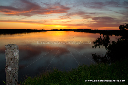
I’m pleased to be able to find a high place with my little boys, our cameras, and our prayers…properly directed on behalf of all who are impacted by the flooding.

Fun flyin’

A couple of weekends ago I was pleased to discover signs pointing to a Bismarck Aircraft Modelers’ fun fly event east of town. The weather was good, the wind wasn’t complicating things, and I happened to have a little extra time after some work on a parade float for July 4th. After we got a couple hours in on the float, I took my family eastward to check on the planes.

The BAM club is one of two in town, and calls the Hoge Island airfield home. Sadly, Hoge Island (not Hogue, local media) is under water right now, so a neighboring club was gracious enough to lend them their field for the day. There were hot dogs and other snacks & refreshments served and it was a glorious day to be out watching the planes. Some of them are capable of speeds over 100 mph, and there were some really interesting designs and pilots as well.

Naturally, my little guys were totally intrigued by this. They asked if there were some that they could fly, but I don’t think putting the controls of a fast airborne object into the hands of a three or four year old is a good idea. I told them they’d have to wait.

I drive little nitro-powered RC trucks – two of them, to be exact. My little guys dig those machines as well, but they’re too young to drive them. Capable of speeds over 60mph, they’re simply too dangerous for children. I do, however, have some old Tyco battery powered RC trucks that are just fine for kids, and they’re getting their training on those. Who knows, maybe someday they’ll be RC pilots!

I’m not sure if it’s one of the BAM guys who created this YouTube video at the beginning of the month, flying over the area north of Bismarck where these planes normally play. It’s an interesting video, though. Of course, now that we’re at 150,000cfs from Garrison alone, and have had plenty of rain, the area is even more inundated with flood waters than in the video.

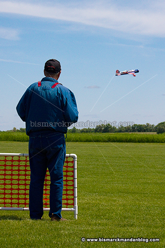
If you’d like more information on the BAM (Bismarck Aircraft Modelers), click here to visit their website at bamrcflyers.org.

Anachronism

This post isn’t just an anachronism because it documents an event held by the Society for Creative Anachronism. No, it’s also an anachronism because I took these photos weeks ago and am only posting them now!

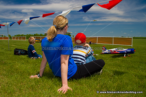
We had just held a little party at Barnes & Noble for my 4 year old because of a reading milestone he’d reached. A picnic was planned to follow, so we took all the friends and cousins over to Sertoma Park to enjoy the day. That’s when we found these folks grillin’ food, swingin’ swords, and generally having a grande olde tyme.

Craftsmanship is key when making a set of armour such as this. I couldn’t help but think “None shall pass!” every time I looked at one of these helmets or other garb. Naturally any Monty Python jokes are well worn at an event like this, so I just held my tongue.

Coat of mail to go with your shield, anyone? This is hand made and very cool. It’s heavy, yet flexible. There were plenty of other creations on display as well, but I’m sure this sort of thing always gets the limelight.

A map of the world, SCA style. It looks like something you might find on the Strange Maps blog, and has some interesting delineation. Just in case you were wondering where we reside in all this:

Look just south of Lacus Sakakawea and you’ll find our general region. It doesn’t look like, according to this map, we’re in dragon territory. Must be all the flooding and shortage of caves.

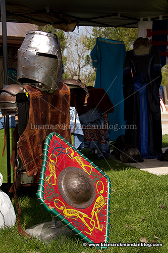
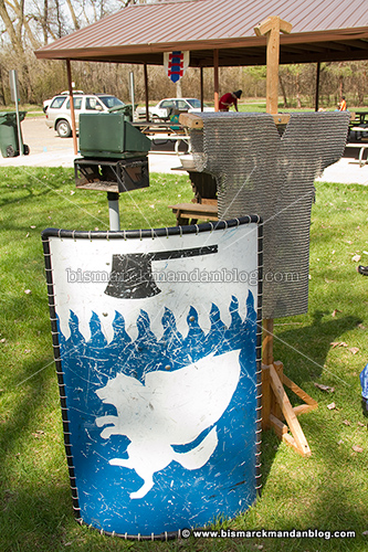
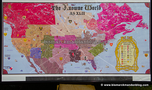
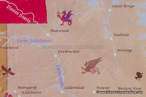
This local bunch of SCA folks was very friendly and hospitable, and it looks like they were having a great time. Want to learn more? Click here to view a map of the Kingdom of Northshield, the SCA region in which their group resides. Tell ’em I sent ye!

Foggy Bottom Boy

After breakfast with some friends last Saturday morning, I ventured south toward the river bottoms to see what sort of photographic opportunities were presented by the morning fog. It was still during the 6 o’clock hour when we wrapped up breakfast, so I was able to get ahead of the sun and sky a little bit. I stopped by this bridge near the entrance to Fort Lincoln and decided perhaps a refreshing morning hike up to the blockhouses would be a perfect way to enjoy the morning.

At first, I expected the blockhouses to be above the fog, since their elevation is so high above the river level. I was wrong…when I got up to the top of the hill, I saw that they were socked in with a thick blanket of fog too. In fact, when I was taking this shot I could see the airborne droplets dashing past my face between my camera and me. It was strange but intriguing, something I hadn’t witnessed since my days of living and working at very high elevation in Montana.

The sun was working on punching its way through the fog, but thankfully I had a pretty good window of opportunity before the morning blanket started to burn off with the rising sun’s rays.

As you can see, from the top of the blockhouse there wasn’t a whole lot of visibility at first.

Slowly the fog up at my level began to dissipate, leaving a thick covering over the river valley below. The sky above was perfect, a beautiful blue and crisp with the morning.

For a brief while I had a little companionship. I have an agreement with the birds; it’s not complicated, but it’s hard to explain. He didn’t care for the idea of me putting on a larger lens to get an extreme close-up. I guess that was the last straw. He left as suddenly as he dropped in.

The sun climbed steadily higher, and with that it dissipated more and more of the thick fog below. As the fog began to recede, the flooding of the Bismarck-Mandan area began to reveal itself.

Soon the view of airborne water was replaced with the view of ominously expanding riverbed water as the Missouri continued to rise and reach out further and further from its normal channel. Vantage points like this are important because they can give a good frame of reference as far as the amount of water we’re dealing with right now.

The fog was suddenly just…gone. The thick covering was replaced by amazing blue skies and a warm, friendly sun. This allowed me to take some photos and video of the blockhouses with brilliant green grass and stunning blue skies. I did plenty of that and then pointed the truck for home.

As much as I like to sleep in, as a photographer I appreciate the morning. You can’t duplicate morning light.if I hadn’t gotten up early, I’d never have seen any of this. As luck would have it, I was able to play with my cameras quite a bit before the clouds rolled in. That’s how I like it.

Hey…this irrigation stuff really works!

I hope a little “flood humor” at a time like this isn’t inappropriate. I couldn’t help but appreciate a little bit of irony at the sight of this irrigation rig up to its wheels in water. This is on the Mandan side, where many of these rigs populate the landscape. From time to time I could see their blue strobes flashing at night from my stargazing vantage point near Double Ditch, and for the longest time I wondered what they were. They’re unlikely to be needed in this area for a while, I presume, or in many other areas around North Dakota.

This raises another question: how many acres in North Dakota have gone unplanted this year due to water-related concerns, flooding or saturation? The answer is scary.

Tale of two ditches. Double ditches, technically

This is a photo from nearly one year ago, taken from one of my favorite Missouri River vantage points: the old fence post at the north end of Double Ditch Indian Village. Pay close attention to this view, because…

…it now looks dramatically different, as can be expected with an astonishing amount of water coming down the valley. All the sandbars, trees, and backwater channels are now simply part of The Big Muddy.

By the way, photos like these just got harder to come by. The reason for that is right here: the ominous ROAD CLOSED sign. Like many scenic areas around Bismarck-Mandan, this area is now off limit to vehicles. Actually, I was surprised to find it open to the public a couple of nights ago when I came up here for some thunderstorm photos. Why, you may ask? Read on.

The cliffs of Double Ditch have been gradually succumbing to erosion for as long as I can remember. Large slabs of dirt occasionally simply fall into the river, and that’s when the mighty Missouri is at normal levels. Now that it’s four feet above flood stage an dmoving at several times its normal velocity, it just got more precarious. I put a camera on a pole and held it toward the edge for this photo, and I have no intention of going back.

It looks like a section of the cliffs further south has collapsed dramatically, opening up a chasm very near to the road. If so, that’s the most plausible reason for the closure. If not, it’s still a wise precaution given the instability of the park’s western edge. That’s not the area shown in the photo above; I didn’t want to walk that far. By the way, this photo was taken by holding out a pole with a camera on the end – I don’t have a death wish.

I highly recommend against getting curious because these cliffs are likely to recede even further as the river takes its toll. I guess the park is one more casualty of the Flood of 2011, even though it’ll never be under water.