An answer to that trio of lingering Memorial Bridge questions you were afraid to ask

I’m curious. That’s one reason I started doing this website: to post the answers to some of the wacky questions I pondered about Bismarck, Mandan, and life in general. Naturally I had a few left over from the Memorial Bridge destruction & construction, which were graciously answered over the weekend by DOT spokesman and fellow KFYR veteran Mike Kopp.

The first one: what in the world happened to all that steel from the old bridge (pictured above)? The answer: “The steel became the property of the contractor, who is in the process of recycling it.” I’m guessing that’s a pretty good deal for them; steel prices have risen steadily in the past few years, from my understanding.

The second one was a combination question: I see a big open slab on the west memorial; is that where a section of the original bridge is going to go, and will there be a similar or identical memorial area on the east side, now that the old footings and stuff are gone? The answer: “A section of the old bridge from the west end will be placed in the Mandan riverside park to be developed. A section of the old bridge from the east end will be placed in the Bismarck riverside park under the bridge to be developed.”

The third one, and I don’t have a photo to back this one up that I can remember: I noticed that the lights under the bridge were only on for a short time, and not all of them were working. Are they off until the bugs can be worked out, or is it a seasonal thing? The answer: “Tests are being performed on the pier lights to determine the best effective radiance.” I can’t wait until they’re on for good. They look VERY nice.

Those are the only questions I could think of pertaining to the Memorial Bridge. It will be very weird starting our first year with the new one. All traces of the old one have gone. We have the new riverside parks to look forward to, however. I can’t wait until it’s warm enough to enjoy them!

November 11th, 11:00 am. 11-11-11. Where were you today?

Today wasn’t very sunny, so one of the features that makes this memorial at the state capitol grounds so special was hampered by weather this year. I was at work anyway, and ran errands over lunch, so I missed it. November 11th is always Veteran’s Day, and this memorial is designed for something special at 11:00 am on 11/11 each year. Here’s how I featured it last year:

I don’t know how many of you folks have looked far back enough to see this post about the Veteran’s Memorial at the state capitol grounds, but this year marks the first time I actually made it to the memorial on Veteran’s Day. As noted in my original post, this monument has a unique feature that displays itself on Veteran’s Day.

On Veteran’s Day at 11:00am, the sun sweeps a path across the metal globe in the middle of the monument. Judging by the number of people waiting to catch a glimpse of this once-a-year happening, I can see it’s no secret.

North Dakota is raised on this globe, and polished. When the sun comes across the globe, the great state of North Dakota shines. It was dull when I inspected the site on Saturday, so I rubbed it furiously to try to shine it up. You’d think someone would have thought of that already, but I guess not.

This is the base upon which the globe sits. Note that the inscription says “the eleventh hour of the eleventh day.” That’s important…

…because I got there late. I mistakenly thought it would be at 11:11. The significance of all those elevens, by the way? World War I ended at 11:00 on 11/11/1918. I mistakenly thought there would be a fourth eleven in the time that the sun was centered on North Dakota. That’s why it’s off-center in the photo above.

Here’s the tube through which the sun shines to reach the globe in the middle of the memorial. It casts about a four-inch circle of light on the globe when fully aligned at 11:00. It appears to have some sort of reflective inside, although I don’t know if that’s true. While the sun is coming through it, it’s hard to look at.

I’d like to pass along a belated thanks to all veterans. Closest to me are my friends Reed and Tony, although I’ve met many others and owe my freedom to millions of ’em. Military service is not something to be taken lightly. The memorial at the state capitol bears the names of North Dakota soldiers who lost their lives in service to their country. If you haven’t inspected this memorial, which has a new parking lot and is just south of the State Library building, please pay it a visit. Once again, the original blog post can be seen by clicking here.

Big Audio Dynamite II

Hat tip to my favorite Mick Jones band for the title of this post. I hiked a long ways today, humping some very heavy gear all over the Bismarck-Mandan area to capture lots of photos. I also had a hand in shooting high-definition (HD) video of the area today too, but I don’t own that footage. Sorry. My personal camcorder was rolling, but the footage didn’t turn out as well as my footage of Span One going down. So I’ll stick to my primary objective: here are the pics!

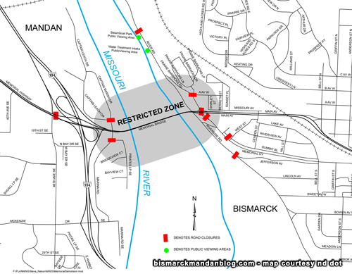
People were lining the hills from above the railroad bridge all the way to the hill north of I-94. Doing so only provided a view of the middle span.

Speaking of the middle span, there was a lot of confusion as to why it came down in one giant piece. I’ll tell you what the explosives expert of the demolition crew told me. Before they install their shape charges, they cut the bolts anchoring the bridge spans to the pilings. They can’t be cutting them with a grinder and sending sparks all over their explosives once they’ve been placed, after all. They had the east span rigged as well as the bottom of the middle span, but then the winds came up. They didn’t want to risk their guys being on the top of the middle span if the wind blew it over, so they opted to drop it and finish cutting it on the ground with torches. Notice that in the days before the demolition, they pushed rocks and dirt out below the bridge. That allows the crews to have land on which to salvage the steel, much easier than hunting around the water.

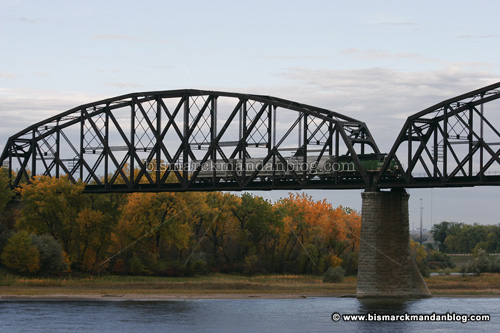
Notice the piece on the right hand side, the top of the pier that underwent repairs in an attempt to help the old bridge limp along. The repaired areas served their purposes, keeping the old bridge in operation until the crews were ready to take ‘er down.

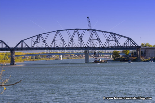
Thanks to the guys who let me poke around a little bit where the cleanup occurred. I liked the arch of this digger reaching over the pillars of the last remaining bridge support. In the background, the big nasty machinery is chewing up the metal as we speak. As of this evening, they pretty much had the east span cleaned up.

How about those jaws? This machine reminds me of that James Bond villain. This guy’s got a pretty fun job, I bet. Chewin’ up steel. I can see how a feller could derive a great deal of satisfaction from it.

By the way, I heard they’re saving chunks of the bridge like this in order to put them in the park on either end of the new bridge. Obviously they have a lot of work to do on those areas, and are making a lot of progress on the west end, but now that the other bridge is going away I imagine they’ll make quick work of the memorial park on the east end too. They just have a lot of rubble and debris to remove first.

Coolest souvenirs of the day: these are pieces of shrapnel from the shaped charges that brought down the mighty Memorial Bridge. I got them from the demolition crew that was doing the aforementioned cleanup. They appear to be copper, and I guess they flew away from the detonation at an extremely high rate of speed. Thankfully these two managed to land in my hands. I’ll keep them forever as a souvenir of the old humming bridge.

Coolest unexpected shot of the day: this guy was flying circles around the area reminding everybody to vote McCain-Palin next week. I’m not going to tell you who to vote for, but I suggest you vote against socialism. Against rabid gun control. Against infanticide. Against domestic terrorists. You get the picture. I Photoshopped this shot to bring the banner in closer to the plane…the drag line was actually a lot longer.

By the way, hats off to Brad Feldman for his coverage of this thing from start to finish. I was present videotaping at the symbolic groundbreaking with Senator Conrad way back when, and I think he was there as well…and he’s followed this project tirelessly. He had cool ideas like putting cameras in one of the houses next to the bridge blast, and loves Bismarck-Mandan as much as I do. I asked my wife to record KFYR and KXMB coverage on DVD here at the house, and can’t wait to go back and watch them both.

So…what’s next? Got anything else we need to blow up?

One more day with you


Yes, that’s right…one more day. The last two spans of the local landmark come crashing down Wednesday morning. Sad, isn’t it? The turnout was so amazing for the last one, I can’t wait to see how many people show up for this one! I’ve got my spot picked out…do you?

Thanks to Mike at the DOT for this map. It indicates the road closures as well as the Safe Zone. If anyone remains in that gray area, the crew can’t pull the trigger. So stay out!

If you want a copy of this map, click here for a PDF you can print and take with you. You’d better come early! There are a lot of eager spectators and the roads are closed before the boom. There were cars down there at 7:30am when I arrived last time!

Goodbye to a familiar texture

I posted this photo, the result of a Photo Club exercise at work, back in August 2006. Less than an hour later, Jason had already guessed the correct location: the bank on 4th and Rosser. Well, the familiar exterior of the bank is changing.

These workers are taking down that familiar jagged exterior and replacing it with some of those new blue-tinted mirrored windows. Jagged panels: old and busted. Blue mirrored: new hotness.

I’m sure they probably figured it was about time, and the new windows are probably more energy efficient, and the bank across the street is remodeling too. But it is sad to see familiar sights around Bismarck go away. That’s the price of progress, I suppose.

One bridge that isn’t going anywhere soon

Since we’ve all got bridges on the mind these days, I thought I’d mention one that has been around for over 125 years in one form or another: the Northern Pacific Railroad bridge, just slightly north of our beloved Memorial Bridges. Built in 1882, it didn’t always have rounded spans and has seen quite a bit of work where it meets the hill on the Bismarck side. The hill moves, and so do the piers. In fact, that part of the bridge has seen some hefty work even in my short lifetime.

It also makes a pretty good sightseeing point when they blow up the Memorial Bridge too, I guess! This guy sat idling for about a half an hour on Monday morning to watch the demolition of the west span of the humming bridge. I guess union membership DOES have its benefits on occasion!

The new Memorial Bridge really is cool, despite not having a walkway on the north side for people who want to enjoy the view. However, with the old Memorial Bridge going bye-bye for good, we have only the Northern Pacific bridge to grace the river with its historic appearance and arched spans. Perhaps the sentimentality local residents showed toward the Memorial Bridge will shift toward the NP bridge, although most of Bismarck-Mandan’s citizens have never crossed it. We do love our landmarks, don’t we?

Boom goes the dynamite

Well, today was the day! I took the morning off for the big event: the destruction of the first span of the old Memorial Bridge. Ever since the new one was started, people have wondered how the old one would come down. It’s particularly tricky on the Mandan side, because the old and new bridges are so close together. Drop the old one incorrectly, and we’ll be picking pieces of TWO bridges out of the Big Muddy! Nobody wants that.

The west span came down in a blaze of glory today, being cut into pieces by shaped charges, and dropped into the drink in 26 large chunks (plus assorted debris).

I staked out a place on the fake riverboat at Steamboat Park early this morning. At 7:30 people were already parked and waiting. I got a great spot, met lots of really neat people, and got some great photos and video. Click below to watch the big bang, both in real-time and slow motion. You’ll hear my camera shutter going mad in the background.


Notice how the camera shook from the shock wave. I don’t think anybody, myself included, expected such an enormous BOOM from those charges!

This is the mess that must be removed by crane over the next 24 hours. I haven’t verified why that is, but with the river so low I suspect that it’s because the Missouri’s flow has been slowed for the occasion. The bottom of the old bridge’s pilings are visible, at least the part that is above the river bed, and I bet that makes recovery easier. My suspicion is that once the cleanup is done, the gates at the Garrison Dam will be opened a little wider and the river level will come up a bit. If anyone has any solid information there, please post a comment!

I have more photos from the event, but those will have to come later. I have to get back to work. Span #2 will come down in a week or so, and I’m hoping to be there as well!

Span number one – coming down Monday

Take a good, long look at it this weekend – this span of the old Memorial Bridge, the west span on the Mandan side, is going to take a spectacular plunge on Monday morning. I expect it to be quite the local spectacle. Yes, I took the day off from work to check it out.

Pay very close attention to this map: the red marks indicate roadbloacks, and the two tiny little green dots indicate good public viewing spots for those who want to be close. The gray area indicates the restricted zone; if anyone is found in that area, the demolition charges cannot be triggered. Law enforcement will be all over this thing, so don’t get any adventurous ideas.

In addition, the navigable river channel will be closed for 24 hours, from around 9:30 am Monday until mid-morning Tuesday. I don’t know the boundaries, but I would expect them to be from the Grant Marsh or NP bridge to the Expressway Bridge. The good rule of thumb is to just stay clear.

Only the west span is coming down Monday; The additional spans will come down later this month. When these demolitions occur, of course the new bridge will be closed (see the map). Plan accordingly. Road closures will be from around 9:45am until 10:30am.

Want resources? Mike Kopp at the ND DOT was gracious enough to pass them along:

A large copy of the above map, in PDF format so it can be printed;

Construction Update (Word DOC) containing work details;

The FAQ (Frequently Asked Questions) about the bridge demolition process (Word DOC).

You can expect plenty of photos and perhaps even video here after I get a chance to parse Monday’s results. After that, we still have two spans to go!

I’ve also heard that a fantastic vantage point is near/in/on the new Energy Center up on BSC hill. I have friends who work in that building who will be glued to the windows when this takes place! I suppose that fancy new building is going to have a lot of noseprints on the inside of its glass exterior.

Spot something goofy in this “antique” picture

I took my wife and boys on a walk along the Mandan side of the river, taking the Missouri River Natural Area trail. We hopped on from the trailhead in the Captain Leach area north of the Memorial Bridge, and I spotted this scene in one of the many backyards bordering the trail. As I framed the shot, I caught something. Do you know what it is?
.
.
.
.
.
.
.
.
.

How many times does “ar” appear in “Bismarck?” I suppose I can’t call it a typo, since this lettering wasn’t typed! I wonder if the artist got a phone call halfway through the word Bismarck or something. Maybe it was painted on International Talk Like a Pirate Day! It never fails…everywhere I look, I find typos. It’s a disorder, I think.

Case in point: we just got our first fancy new high-definition video camera last week. I opened up the operations manual from Sony and…yep! Typo! I guess it’s a good thing that my spelling and grammatical “spider sense” still works.

I experimented with giving this photo the faded look of an old print by desaturating it and giving it a slightly different gamma curve. I love playing in Photoshop and haven’t really had much to do with it lately. Time to step it up, I think…those skills can get rusty when not used!

Sixty years ago, North Dakota nearly bordered FOUR states

Not much can be easily found with merely a cursory Google search, but there are those souls on the Internet that love chasing down such details. I was tipped off to this by a blog I frequent, Strange Maps.

Apparently a few disgruntled folks were looking to make a state of their own back in the 1930s, borrowing bits from Montana, Wyoming, and South Dakota. “Absaroka” would have been the 49th state, cutting in line ahead of Hawaii and Alaska, a.k.a. “Seward’s Folly”.

The name Absaroka is tied to the Crow Nation, according to this article from the New York Times. (Of course, we know how reliable THEY are…I’d rather trust a blogger!)

Apparently these folks were quite serious, even to the point of printing up state license plates (as pictured above), and even a Ms. Absaroka contest (as pictured below).

I wonder what Montana, Wyoming, and “the other Dakota” would have thought about losing a big chunk of their territory to this new state? I can hardly imagine they’d be thrilled. And of what serious offense would the instigators of this movement be guilty? Not secession, at least on a national level. In any case, it must have fizzled out. The last time I headed south of Belfield, the signs said South Dakota.